Monday, August 22, 2016

Seven Pass Loop

Southbound PCT from Harts Pass
After weeks of plotting and waiting for the right weekend, Apryle and I finally made our way into the Pasayten Wilderness. Once we were in it, the allure of the place made it difficult to find the motivation to make our way out of it. We arrived at Harts Pass Campground on Friday morning and immediately hit the Pacific Crest Trail (PCT) southbound for a warm-up twenty miler in preparation for our longer Seven Pass Loop which was slated for the next day. We were careful to pull in the reigns on the pace in order to save energy and were treated to spectacular views after only two miles on the trail.
Northbound PCT from Harts Pass

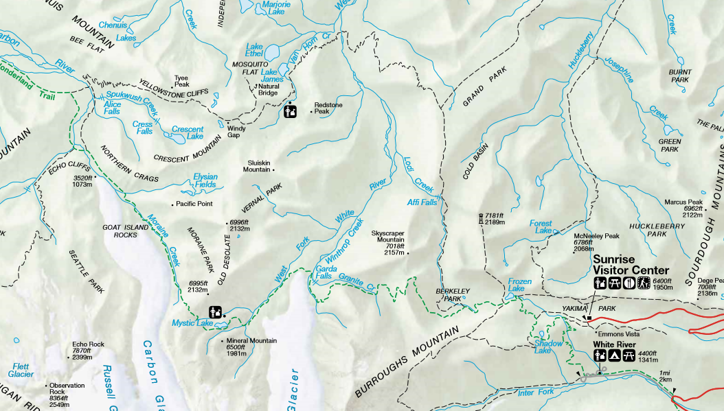
It is quite amazing how gradual and rolling this section of the PCT is given the surrounding landscape. It often takes 10-12 miles of hiking through tree covered mountain sides to get the views that we had the entire run. We passed by Tatie Peak, peered out into the Trout Creek Valley, chased down the ever looming Ballard Mountain, and descended toward Glacier Pass before headed home to refuel before our Seven Pass mission.
Apryle on Seven Pass Loop

We awoke on a chilly Saturday morning, broke camp, cooked up some oatmeal, double checked our packs and made our way out from northbound PCT trailhead. The trail was quite flat, surrounded by wildflowers and offered stunning views of the valley below us. The first 15 miles of the trail was quite manageable, only 1700ft of vertical and the trail was well groomed. We had a few switch back ascents, but it seemed like we were mainly weaving our way downhill the entire time.
Holman Trail Obstacles

We passed along winding alpine trails that were easily traceable from a distance, crossed upland creek beds, and passed through densely covered pine forests until we reached our turning point onto the Holman Trail. We traveled over Buffalo, Windy, Foggy, Jim and Holman Passes, though I could not tell you which portion on the trail was actually the pass. We were surprised with how quickly we had covered the first half of the trip and hoped the second half would continue just as smoothly.
Refueling at Oregon Creek

However, in the latter half of the PCT and beginning of the Holman trail I was stung by a bee on two separate occasions on both of my ankles. This was only a minor annoyance but we hoped it would not be a sign of bad luck to come. Our nutrition and hydration was on point, we both carried 2 L camelbacks with a few hundred calories of Tailwind and I carried a dozen oatmeal chocolate chip bars we made a few nights prior. We only had to stop once to refill water (and purify with iodine), at Shaw Creek about 17 miles into the journey.


Apryle & I at Oregon Creek
The Holman trail was a little overgrown in places where the grass attempted to reclaim the bare soil. There was also quite a number of fallen trees and muddy stream crossings that turned this stretch of trail into a bit of an obstacle course. However, in my opinion, it is not a Pacific Northwest hike without at least a few miles of downed trees to climb over and few muddy creeks to traverse!
West Fork of Pasayten Crossing


We had not realized that we were already on the 472 trail along the West Fork of the Pasayten until my GPS map revealed that we were paralleling the PCT trail. The Shaw, Oregon and West Fork crossings were harmless and we stayed dry with simple rock hopping techniques. The trails looked muddy but the ground was actually quite solid and the imprints of several woodland creatures were preserved in the packed earth.
Last Stretch toward Slate Peak


The trail along the West Fork of the Pasayten was full of buried longs that made it seem like we were running over an abandoned railroad track. It actually was a convenient match up with our strides. Along this section the sun broke through the trees and we caught glimpses of the ridgelines bookending us.  Along the trail there were odd looking stacks of wood and metal piping that appeared to be props for an ongoing trail project.
Last Stretch with Valley View

The trail remained very easy a flat from the start of the Holman trail up until we made the turn for the ascent up Slate Peak. At this point I finally began to get the vertical ascent numbers I was looking for the entire trip. The trail pitched up through the dense forest and broke free into the alpine. Once again we were surrounded by foot tall wildflowers with sweeping views of the vast valley below us.

On Slate Peak

This pleasant surprise brought the Seven Pass Loop into the number one spot surpassing our previous favorite – The Outer Mountain Loop in Big Bend National Park. The trail turned from a carpeted flower bed to a rocky talus field as we reached the Slate Peak trailhead. Here we made the final ascent that would lead us to the top of Slate Peak and the impressive skyline that awaited us. After a total of 6,250 feet of vertical and 27 miles of running we made the last descent to the car parked at a switchback on the road below.
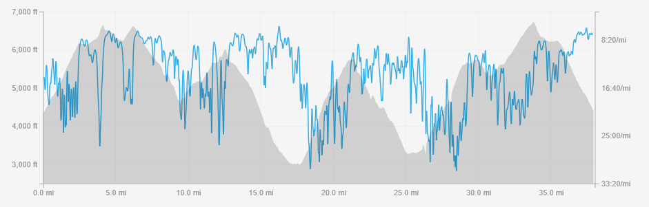
The Stats

Seven Pass Loop
Elevation Profile (Strava)
Friday August 19th 2016
20.1 miles
3:45:05
2,953ft Vertical
Seven Pass Loop Map (Strava)


Saturday August 20th 2016
28.0 miles 
6:17:01
6283ft Vertical 

Tuesday, August 16, 2016

Cougar Mountain Marathon

Craig-Szablewski Wedding PC Johnny Vogel
After a nineteen week hiatus from competing in a race, it was finally time to toe the line once again. It was far from an uneventful break however, in the time between races, I passed my PT board exam, traveled back east to get married, traveled around Peru for a month and landed my first PT position in Okanogan County.
I decided that the Cougar Mountain Marathon in Issaquah, would be the best choice for a tune up race before the IMTUF 100. Although the race location required a lengthy drive across the state, Apryle and I were able to stop in Peshastin Pennacles State Park for some climbing the day before the race which broke up the monotony of the road.

Climbing Peshastin Pennacles
The past two months I have been focusing intently on vertical gain, time on the feet and a weekly long run. In my first two hundred mile attempts I focused on high weekly mileage without a standout long run, which gave me subpar results. Therefore, in the lead up to my third hundred mile race, I have been altering my approach.

The Cougar Mountain Marathon would serve as a measuring stick in terms of pacing on a hilly course and also serve as one of my weekly long runs. I had run in the area a few times prior when I lived in Seattle, so I was familiar with the trails. However, I have rarely run at Cougar Mountain without getting lost, the race was no exception.


Adam & I Pre Race
I started out quick to build a lead early, that I could hopefully hold onto throughout the later stages of the race. Unfortunately, I took my first wrong turn about 7 miles into the race and lost my lead. I was forced to back track and reel back in my competitors. I was able to build up a few minute lead before the turnaround section when I was able to see their position on course relative to mine.


Onto the Trail
Around the halfway point in the race on longer loop section I realized that I made a costly mistake taking only a 17 ounce handheld. I assumed after running in 100+ weather on the east side of the Cascades, I would be well equipped to handle the cooler weather on the west side. Furthermore, I can think of very few times I have even taken water with me on a race as short as the marathon, let alone a hydration vest. But I believe that my abysmal pace in the last few miles was due in large part to dehydration.


Apryle & I at McLaughin Canyon
Not only was I dehydrated, it seemed that the course was swept in some key areas for the final loop. I took a few more wrong turns, and was forced to use the map feature on my garmin to navigate the course. This worked fairly well and at the final intersection I caught a glimpse of the second place runner who was also having a difficult time navigating the course. I kicked it into gear on the last mile and managed to pull out the win with a few bonus miles along the way.


Course (Strava)
With the exception of my poor hydration strategy, the bonus miles, and the slow time; I really enjoyed the day. As always my wife was there to support me and cheer me on to the finish. My good friend Adam Braddock was there running the 14 miler and cheering me on to the finish as well. The aid station volunteers were extremely helpful and course terrain, scenery and topography made the entire journey a worthwhile experience.


Cougar Mountain Marathon
Elevation Profile (Strava)
Post race recovery consisted of a 20 mile run on the Tonasket back roads and Carter Mountain Natural Area trails. This was made much more manageable with some company from Apryle on the latter half of the run. In the end I was surprised how well my legs recovered from the previous days effort. Overall I was quite happy with my 26/20 back-to-back and look forward to a few more prior to the hundred miler in mid September.

Training Stats


Month Dates Mileage Time Vertical (ft) Long Run
April 3 to 9 21.36 5:43:35 4,085 8
April 10 to 16 49.26 8:04:11 5,918 7.11
April 17 to 23 68.67 11:01:07 7,680 20.01
April 24 to 30 47.54 6:33:28 4,750 20.05
May 1 to 7 68.14 10:18:53 7,805 12.63
May 8 to 14 74.31 10:20:52 9,937 16.96
May 15 to 21 68.63 9:43:18 6,959 10.07
May 22 to 28 62.46 8:54:01 5,178 10.01
May 29 to 4 77.76 10:52:51 3,675 16.16
June 5 to 11 51.91 13:13:21 12,844 12.41
June 12 to 18 25.82 9:41:11 8,464 8.99
June 19 to 25 83.21 22:49:55 11,539 17.43
June 26 to 2 63.14 8:31:58 2,982 10.1
July 3 to 9 95.55 18:31:29 13,494 26.1
July 10 to 16 75.52 11:33:38 10,643 18.37
July 17 to 23 75.75 12:51:59 7,779 20.06
July 23 to 30 89.36 17:25:04 23,556 39
August 31 to 6 61.62 8:32:27 10,640 11.6
August 7 to 13 66.87 10:28:29 10,883 26.25
19 Weeks 1226.88 215:11:47 168,811 39

Monday, August 8, 2016

The Northern Loop

Descending PC Adam Braddock
Foreword

After our move to Washington, Apryle and I began scheming and planning for all the amazing hikes, climbs, and kayaking trips we were going to undertake for the year. As is typically the case we had to make concessions for other things in life that take precedence. One of the plans that had to go by the wayside was my attempt at an assisted speed attempt around the Wonderland Trail. Because we unexpectedly moved to eastern Washington, we were unable to do much hiking on the west side of the Cascades, therefore, my would-be pacer Adam Braddock and I decided to do a 30-40 mile trail run at Mount Rainier. We settled on the Northern Loop and joked that we would be setting an FKT because we were unable to find record of anyone else completing the loop for time.

Adam & I with Rainier Looming PC Adam Braddock

So Apryle dropped us off at the White River Campground Trailhead to avoid the ten-mile drive to the traditional Sun Rise Campground starting point. We started in the late morning hours when the sun was already engulfing the area and heating up our surroundings. The loop would end up looking more like a lollipop with our modified starting point, but we had not anticipated how much this additional lollipop stick would add to our day. When Adam and I reviewed the trail description it said around 33 miles and about 8500ft of vertical; which we thought would be a solid 6-6.5 hours of running. However, our new starting point and challenges we encountered en route would tack on an additional 6 miles, 5000ft of vertical and 4 hours of movement (depending on whose watch).

Enjoying the View PC Adam Braddock
Chapter 1: White River Campground to Wonderland Trail


The first leg of the run was more of a power hike, with over 2000 vertical feet in just over 4 miles, the trail certainly does not ease you into it. We wanted to be conservative early because we knew we had a lot of ground to cover and that too quick of an effort early could cause problems later on in the run. Once we started on the looped section we were greeted with sweeping views an alpine landscape.

Mystic Lake PC Adam Braddock
Chapter 2: Wonderland Trail to Northern Loop Trail


The second leg of the journey included some faster rolling alpine miles that were completely above tree line. The alpine sections are always my personal favorite because I enjoy the views that are unobstructed by trees. I have always loved to trace the slender outline of a trail winding among the mountains and upland vegetation in the distance. These sections never last long enough, as soon as we reached the 6500ft it was back down into the forest we went. We kept a solid pace and Adam told stories of the Seattle running scene in the 2000's until we popped out at a Mystic Lake (or so the sign informed us). From Mystic Lake we continued along Moraine Creek and made the most our most dramatic descent (3000ft over 5 miles) of the run all the way to the Carbon River Suspension Bridge.
PC Adam Braddock
Chapter 3: The Northern Loop Trail to Windy Gap
What goes down must come back up; and we knew that would be the case on the stretch of trail to Windy (Winded) Gap. In this case we ascended around 2700ft in about 3 miles up a switchback tree-covered mountain side. When we reached the top we assumed this would be the last big climb of the day (based on total vertical gain calculations) and were quite excited about our pace. We were once again in my favorite place - the alpine. The wildflowers were spectacular, the trail was runable and the views were breathtaking. I made good use out the lifestraw in the crystal clear mountain streams, while Adam captured the scenery with his camera-phone. Life was good and we were just remarking about how we missed our wives and were ready to pick up the pace and get home.

Tree Obstacles PC Adam Braddock

Chapter 4: Windy Gap to White River Crossing


We ran at a solid clip down the hill from Winded Gap until we made a half mile error near Lake James. It was at this point when the trail markings got very sketchy. Prior to Lake James we were confident about our sub seven hour effort, but this juncture marked the only the beginning of our troubles. After getting back on trail we were slowed to a walk by a constant barrage of fallen trees. We could not go ten strides without having to hop over or climb under fallen logs that made trail finding a challenge. After we emerged from the obstacle course, we arrived at Van Horn Creek and saw a spectacular waterfall, but it seemed that the obstacles were only beginning. From here the trail stopped, we followed sporadically placed cairns to the West Fork of the White River. The cairns indicated that we must cross the raging knee deep water. Adam made quick work of the crossing but I was quite scared, one slip might send me down stream to get caught on a log jam. I feared getting stuck under a log and drowning, but I knew if we turned back we would undoubtedly be hiking in the dark, so I pressed forward.

Rainier PC Adam Braddock
Chapter 5: White River Crossing to Berkeley Park


After we made it safely across the river we had to find the trail, luckily we saw an old red hat and a few other clues that lead us back to the trail. Once back on the trail the fallen trees continued to hinder our pace and we also saw the final climb that was assured to slow us to a hike. The last climb once again followed up a 4 mile tree covered mountain side that switch backed over 2400 vertical feet. We passed a few others that were tackling the loop and were reassured that it was all downhill from there.

Upland Meadow

We finally reached a clearing that offered one last view of Mt Rainier and then emptied into another upland meadow. At this point we were able to open up the stride once again for about 3 miles before steadily climbing another 1200 vertical feet. We were surrounded by beautiful mountain streams and wildflowers, the temperature was cooling off and we were so close to finishing one of the most challenging looped trail runs either of us had ever done. It was in this stretch where we also spotted our first and only black bear on the trip and here where we realized that the run was going to run drastically over the time that we were hoping for.


Bear Among the Wildflowers PC Adam Braddock
Chapter 6: Berkeley Park to White River Campground


This section skirted along the alpine where there were still remaining strongholds of snow and eventually led back into the forested switchbacks that would lead us back to our destination. Here Adam and I really picked up the pace and finished strong. I was trying to keep up as the pace reached a quick 7:30 over roots and rocks on the ever dimming trail. We made it to the finish as darkness was falling around us. It ended a long and arduous journey that consumed every inch of our energy. The run was beautiful and exhilarating but I could not help but be overwhelmed with guilt for arriving so late the night before Apryle's White River 50 miler.


Epilogue


The Final Stretch PC Adam Braddock
Depending on what site you find there are a lot of different measurements for distance and elevation gain of this loop. I have seen this distances ranging from 33 miles to 40 miles and elevation from 8500-9500 total feet. Even Adam and I came up with different final results despite never more than 100 feet from each other the whole time. At any rate, to provide some beta from our most recent journey the stats are listed below:


Hiking the Northern Loop at
Mt Rainier (NPS Map)
Adams stats:
Miles: 39 
Moving Time: 8:34:11
Pace: 13:09 
Vertical Gain: 12,079 feet 
Total Trip Time: 10:35:21
Hiking the Northern Loop at
Mt Rainier (Strava Map)


My Stats:
Miles: 38 miles
Moving Time: 9:06:11 
Pace: 14:22 
Vertical Gain: 13,125 feet Total Trip Time: 10:35:21 


Elevation Profile for
Northern Loop at Mt Rainier (Strava)

Since we were unable to find another documented FKT; Adam and I will take credit for this one in a time of 10:35:21... should be easily beaten when logs are cleared off the trail and river is shallower. 

As a side note Apryle went on to do a spectacular job in her race the next day; here is a link to her race report