Here are some photos. Narrative to follow at a later date! |
| We saw about 13 figures plus the aqueducts while flying over the mysterious Nasca Lines. |
 |
| Zach is trying not to look as sick as he feels. Despite taking a Dramamine, I'm not in much better shape. |
 |
| Feet back on solid ground! |
 |
| While in Nasca, we did about a 5 mile run that visited 3 historic sites including Paradones. |
 |
| On our run we also visited aqueducts we saw from the plane. Possibly built by Pre-Columbian Nazca architects around 540 A.D. in response to two prolonged droughts during that time. |
 |
| Ascending to Inca ruins above Ollantaytambo, with the terraces of Ollantaytambo Fortress visible in the background. |
 |
| The Inca ruins of Pinkuylluna were used as Inca storehouses. It was free to visit this site and only about a quarter mile from our hotel. |
 |
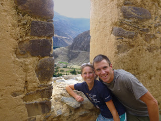
| Looking through a window at Pinkuylluna, with the Fortress in the background. |
 |
| The next day, we hiked to more free ruins. As we approached Pumamarka ruins, a farmer gave us permission to hike through his field. |
 |
| Looking down at the canyon from Pumamarka. |
 |
| Zach made friends with the natives at Pumamarka. |
 |
| We hiked up to Machu Picchu from Aguas Calientes, and our effort paid off with tourist-free views. |
 |
| We immediately hiked to the Sun Gate to watch as the light first splash color onto the Lost City of Machu Picchu. |
 |
| The ruins were incredible, and the surrounding jungle mountains were, also. |
 |
| Llamas graze amidst the ruins. |
 |
| Those Incas know how to choose a good view. |
 |
| Machu Picchu is home to myriad flora and fauna. |
 |
| The trip was full of birding. |
 |
| Temple of the Three Windows. |
 |
| This stone kept time. |
 |
| Wife and husband. |
 |
| We watched restoration crews repack mud into some of the walls. |
 |
| Some walls were so intricately carved that the blocks fit seamlessly and no mortar was necessary. |
 |
| Machu Picchu was built into an impossibly steep mountainside. |
 |
| The hike from Aguas Calientes to Machu Picchu follows a stone pathway made by the Inca. |
 |
| Our Cordillera Huayhuash hike started in Llamac and ascended to this first stark pass. |
 |
| Lots of grandfather cacti. |
 |
| Day 2, the wind nearly knocked us over as we hiked up and over a steep pass. |
 |
| The next drainage held spectacular views. |
 |
| The rocky, arid landscape was bursting with purple lupine. |
 |
| Camp at Curtelwain, where giardia symptoms hit hard. |
 |
| We got a bus back to Huaraz, watching movies in Spanish and resting. We could hear the honking of taxi drivers and barking of dogs on the bustling streets below our hotel window. |
 |
| Huaraz market |
 |
| Huaraz market |
 |
| Huaraz market |
 |
| We headed to an alpine hostel called The Hof to finish recovering from giardia and get a few hikes in in the Cordillera Blanca. |
 |
| We couldn't wait to get back on our feet, and immediately hiked to Laguna Churup from our hostel. |
 |
| After an ascent that used ropes over rocky slabs like the Via Ferrata, we reached Laguna Churup. |
 |
| At 14,600 ft, and still very weak from giardia, Laguna Churup was a tough warm up. |
 |
| Giant hummingbirds loved these huge blooms on the hillside behind The Hof. |
 |
| The next day, we planned an easy exploration and recovery day up Qedabra Cojup. |
 |
| But as the scenery tempted us to press on, our recovery day turned into a 17 mile roundtrip. |
 |
| Zach sporting his giardia. |
 |
| The return trip was just as beautiful. |
 |
| Our next big hike from the Hof was up to Llaca. |
 |
| The glacial melt forms sparkling lakes. This lake has a dam to protect Huaraz below from flooding. |
 |
| The crystal clear, brilliant blue stream hid the effects of cattle. |
 |
| Finally we explored the beaches of Lima. Lima is the most grey, overcast place I have ever been. |
 |
| We checked out the birding at Villa Marshes about 11 miles south of Lima in a district called Chorrillos. |
 |
| We rented a boat and to our suprise a guide came with it. Though I do not know the English name, our guide call this bird a Wacu. |
 |
| Layover in Las Vegas. |


No comments:
Post a Comment